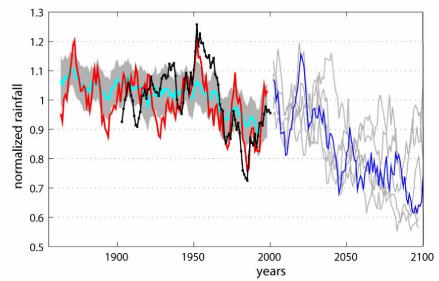
Droughts are a recurring environmental problem in the Sahel region of Africa -the semi-arid area to the south of the Saharan Desert and north of the rainforests of Central Africa and the Guinean Coast. Generally receiving less than 500 mm of rain a year, the Sahel experiences sizable rainfall variations, year-to-year and decade-to-decade. Following a relatively wet period in the 1950s, the region endured a severe drying trend into the early 1980s, during which annual rainfall amounts dropped by 40%. Large-scale famine ensued. Since the early 1980s there has been partial recovery, but future prospects are uncertain. (reference)
The Sahara Desert is moving south and taking over areas that just decades ago were savanna or forest. Some of the most striking changes have happened in Lake Chad. Just 40 years ago, Lake Chad encompassed 25,000 square kilometers and fishermen would take over 230,000 tons of fish out of the lake every day. Today, the lake has shrunk to 500 square kilometers and the daily catch has dwindled to about 50,000 tons. People are now farming in areas that just decades ago were submerged. (reference)
As depicted in the following Figure, the simulation models project a drier Sahel in the future, primarily due to increasing greenhouse gases. If this projection of long term rainfall reductions occurs, Sahel droughts would be more frequent and severe than in the 20th century. (reference)
You want to share some ideas, or data with the visitors of the Corrosion Doctors Web site please send a note to our
Climate tipping points: Amazon Rainforest, Arctic Sea-Ice, Atlantic Thermohaline Circulation, Greenland Ice Sheet, Sahara/Sahel